Finding the beauty within an industrial wasteland
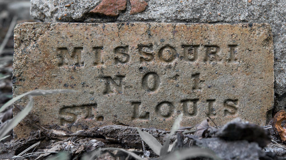
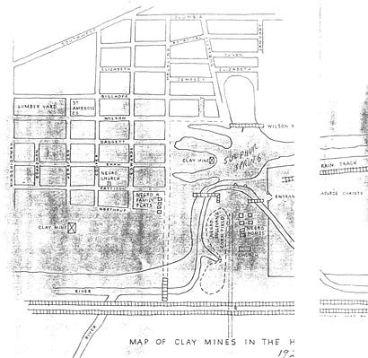
Thanks for reading Story Cauldron, where I investigate stories and storytelling. If you enjoy what you’re reading, please consider sharing this newsletter with a friend. Finding the beauty within an industrial wastelandGeek out with me as I fall down a local history rabbit holeToday I’m going to do a dive into a sulfur spring. (Not literally!) Let’s look at a time when St. Louis looked a lot different than it does today, ponder how industrial development changed my hometown, and learn tidbits that will work their way into my novels. Now, on with the show! I often think about the places that are lost to history, and imagine how things have changed over time. With each technological advancement, as money comes and goes, and as people move in and out of an area, there are innovations and renovations, and demolitions. Houses turn into parks while wild areas turn into shopping centers. And so many rivers and other natural spaces are destroyed. And along the way, people forget what used to be. As a historian and a storyteller, I decided to set my Favor Faeries novel series in St. Louis, and have sought unusual locations for many scenes. On one “location scouting” expedition, I discovered a bridge and couldn’t figure out why it was there. I still haven’t completely answered that question, but it’s opened up a whole lot of history, and I keep falling down the rabbit hole. The discovery of the bridge inspired me to investigate the history of a sulfur spring that once existed in the area southeast of the intersection of present-day Manchester and Hampton here in St Louis. While you may not know the area, there was likely a similar location in your hometown, as ‘progress’ happens everywhere, so while the details will differ, the general flow of time will likely be the same. The magical sulphur springsIn the early 1800s, St. Louis was a thriving city along the Mississippi, but most people lived within just a few blocks near the river. The sprawling hills west of St. Louis was already home to the Osage, the Kiikaapoi, and others, but for the settlers from Europe, it was space to leave their mark. As a result, wealthy men who wanted land of their own pushed westward into the River Des Peres valley. This was a time when the River Des Peres (now a fetid channelized river that is barely more than an open sewer) was still “a clear crystal stream” and a “thread of silver sheen” that “stretched a serpentine course through groves, orchards, farmlands, broken abruptly at intervals by a delightful vista of bluffs, hills and valleys.” The land around the river was thick with oaks and pawpaws, sycamores and cottonwoods, with wild apple trees and blackberry thickets, and deer and elk regularly visited and pawed at the muddy banks of the streams. But for settlers, the defining characteristic of this particular area was the sulphur spring, said to provide great health benefits to those who bathed in its waters. According to journalist Walter Barlow Stevens, “horses and cattle at astute went a long distance to drink the sulfur water in preference to any other.” By all accounts, it was an absolutely wonderful place to be. Charles Gratiot obtained a land grant to the area from the Spanish in 1785, which became the Gratiot League Square. He built a country house there in 1790, though he and his family lived mostly in the city. But his efforts put the area on the map, and slowly others joined him. In one noteworthy case, English naturalist John Bradbury had also built a home near the spring by 1819. Soon, Sulphur Springs became popular with the well-to-do St. Louis crowd, who lived a mighty six miles away (a round-trip would take nearly a day by carriage via dirt roads). Despite the distance, according to an article in the St. Louis Post-Dispatch, “its romantic woods and medicinal waters soon became an attraction for the more ambitious picnickers and pleasure seekers, and a hotel was built.” The hotel was followed by bathhouses in the spring of 1852. In 1858 the Icarians, French communalists, settled in this area with 200 followers, adding considerably to the population, although their community fell apart by 1864. We don’t know exactly where the spring was located, but here’s a map drawn back in 1923 by a man who lived and worked in the area, and would have seen the springs as a boy. It’s our best documentation for where the spring was located.
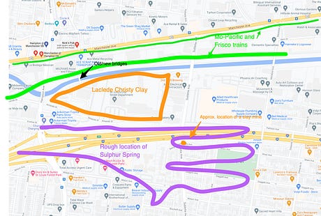
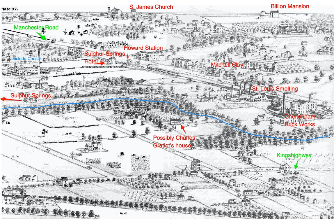
For those familiar with the area, here’s my attempt to apply the locations of the above map to a current map of the area solely for reference purposes. It was a lovely area that even in 1875, with a railroad line, a smelter, and at least three brickworks, hadn’t yet turned into the heavy industrial area that it would become.
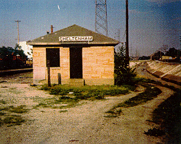
The first train westBy the middle of the century, the area around the sulfur springs had been christened Cheltenham. It was a testament to the popularity of this location that in 1852 the Pacific railroad built the first tracks west of the Mississippi right to Cheltenham. For the journey west, a new locomotive had been built in Massachusetts and arrived in St. Louis via New Orleans aboard a steamboat. On December 9th, the first train left the station in St. Louis near 14th Street and Chouteau Avenue and traveled to the terminus near what is now the Hampton Road viaduct. As Rev. P.J. O’Connor wrote, “At Sulphur Springs speeches of congratulations were made by Mayor Kennett, Edward Bates and James H. Lucas, and lunch was served at the local hotel.” The Republican, a local paper, hailed it as "a new epoch in the history of our state." And as noted on an official St. Louis site, the railroad “made Cheltenham a bit of a boomtown, since it now had, or would soon have, ready access to ways to move its firebrick to eastern factories.” Industrial RevolutionQuality fire-brick clay was discovered in the area in the mid-1800s, and soon the whole area was teeming with mines, massive kilns, and smokestacks as clay mining and manufacturing mingled with smelting and related industries. In 1844 the Laclede Christy Co. built a small fire-brick kiln near the sulphur spring and the railroad, and soon it was a thriving business, with clay mines being dug throughout the area to the south and southeast of Forest Park. And with a river and natural springs, there was quite a bit of groundwater to contend with. As clay worker Mario Torretti recalled in 1926,
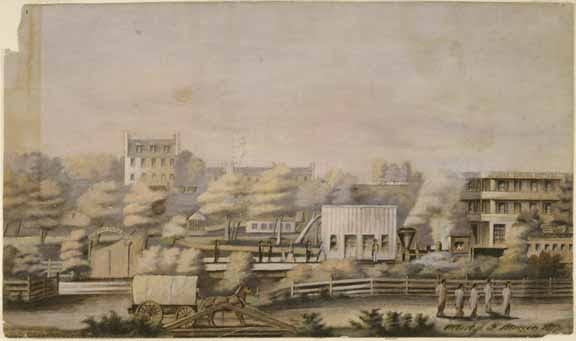
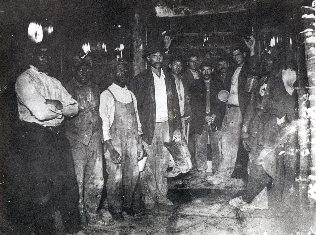
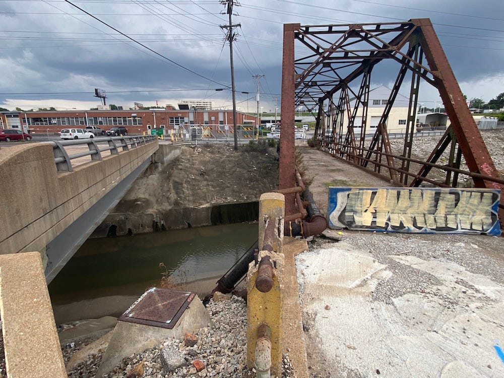
Initially, as the above image and the black and white 1875 sketch both demonstrate, the area was still somewhat rural despite the new industry. But in time, clay works and other businesses would line both sides of the River Des Peres and spill into the neighboring countryside. Sulphur springs > the railroad > clay > peopleSuch tremendous industrial growth was great for the city, as the various clay works produced sewer pipe, fire brick for kilns, and other bricks that would be used in the construction of hundreds of homes and businesses in the area—and shipped all around the world. All of the clay works (as well as coal and rock quarrying and smelting) employed thousands of people throughout the city to do the difficult and dangerous work of mining and manufacturing, working around kilns that reached very high temperatures. In the area, those jobs fell to recent Catholic Irish and Italian immigrants as well as freed slaves, all of whom faced likely discrimination and unemployment otherwise. And in those days, everyone worked side by side in the mines. (If you’re curious, here’s a list of over 100 mines in the area.) These people and turn built their own neighborhoods around the mines. As Torretti’s hand-drawn map indicates, there was a small African-American community in proximity to the clay works. The Irish, meanwhile, tended to settle mostly to the north and west (what is colloquially called Dogtown) while the Italian workers formed a tight-knit community on the hill to the east that overlooked Cheltenham, which today is just known as The Hill. The industry provided jobs, but it led to the destruction of the natural wilderness. Clay manufacturing had dozens of kilns belching out thick smoke. With the railroad, companies also started sending unrefined gold, silver, and lead ore to St. Louis, where smelting companies, such as the St. Louis Smelting and Refining Co., right up the river from the Laclede Christy Clay Works, refined metals into bars and ingots. Like clay, smelting also required massive furnaces, and it had the unfortunate problem of producing toxic arsenic as a by-product. The air became clogged with smoke, and the mining and runoff polluted the river and the groundwater. The Sulphur Springs and the River Des Peres that had drawn people to this area were ruined, and the fate of the area as an industrial wasteland was set. Such was the march of progress. In many ways, these developments made St. Louis the city that it is today. Without the discovery of clay and the city’s ability to become one of the world’s biggest producers of bricks, St. Louis would not have been quite the industrial powerhouse that it was in the late 19th century. But the developments left their mark on what was once the most lovely area outside of downtown. What’s there today?I’d love to report that since the decline of the clay industry and the shuttering of the smelters in the mid-20th century, the land around the River Des Peres and Sulphur Spring has been allowed to return to its natural state. Unfortunately, as is the case throughout the city, land once used for heavy industry continues its impervious cover and lack of vegetation. Most of it is either light industrial (no more smokestacks) or commercial use to this day. And in a sad triumph of mankind over nature, there remains no trace of the sulphur spring, which must have been drained as a nuisance sometime between the mid-1850s and 1878. Meanwhile, from 1924 to 1933, the River Des Peres was drained and rerouted, with part of it channelled underground, as a flood-mitigation effort that only partially succeeded. For a visual look, here’s what’s left. Below is a photo I took of the bridge that started this journey and its modern counterpart. (It’s pretty representative of the entire area.) On the other side of the poor river is the St. Louis Street Department and just beyond that, I-44 runs east to west. How does this have anything to do with my fiction?If you’ve read this far, you might be asking yourself this question. The iron bridge in the photo above is a setting in my Favor Faeries world. More than that, the pre-industrial landscape factors in, as my characters find themselves in a place that is both familiar and completely foreign. It’s not historical fiction or time travel, but for what I’m writing, knowing what came before colonization is very helpful to my world-building. So while it may feel like a complete diversion to be talking about a small plot of land in St. Louis 150+ years ago, it actually has direct relevance to the stories I’m writing. Thank you for going on this journey with me. In future newsletters, I’ll explore the history of mounds that native people built throughout St. Louis and Illinois in the 13th century, as we;; as the history of the River Des Peres, the great flood walls along the Mississippi, and so much more. Sources:Bob Corbett, Sulphur Spring -- Later Cheltenham And Dogtown.Jim Creighton, “A Forgotten Landscape of St. Louis,” St. Louis Post-Dispatch (1923-2003), 01 Feb 1978: 61. Bob Corbett's reprint.“Capt. William Sublette,” St. Louis Post-Dispatch, 5 July 1891: 23.“The Clay Mines of Saint Louis,” Rome of the West.“In Cheltenham Valley, a Sooty Suburban Town that Began Existence as a Watering-Place,” St. Louis Post - Dispatch (1879-1922); St. Louis, Mo. 09 Dec 1888: 21.“Miss M. T. Gratiot lived in the same house 67 years” St. Louis Post-Dispatch, Oct 6, 1913 p. 11Rev. P.J. O’Connor, The History Of Cheltenham and Saint James Church, 1937Tim O'Neil, How a 5-mile train trip from downtown St. Louis changed our nation's history in 1852, St. Louis Post-Dispatch, Dec. 9, 2021.Louis Schmidt, “South Cheltenham.”Walter Barlow Stevens, St. Louis – The Fourth City, Vol 2. Originally published in 1909, republished in 2020."Underground Coal and Clay Mines in the City of St. Louis"1875 MAP OF CHELTENHAM AREA (PRE-DOGTOWN NAME AND AREA), originally in Compton, Richard J.; Dry, Camille N. (Pictorial St. Louis) Composite, 1876; original annotations by Bob Corbett.You’re on the free list for Story Cauldron. For the full experience and to be the first in the world to read my next novel, consider becoming a paying subscriber. |
Older messages
Pulling myself out of the swamp
Tuesday, December 7, 2021
It's always important to know where your towel is
The Unblinking Eye
Tuesday, November 30, 2021
Flash fiction about a woman growing older
Thanksgiving stories
Tuesday, November 23, 2021
In this week's Story Cauldron, I want to hear from you: What is your favorite Thanksgiving memory, and what's your favorite part of the Thanksgiving meal?
Writing in a whirlwind
Tuesday, November 16, 2021
A little insight into what it's like to work on a novel when you're also writing other things
The Boy Who Can Taste Color Ch. 4
Friday, November 12, 2021
Where we learn what Travis has been keeping secret through the holidays
You Might Also Like
Closing Tonight • Black Fri TO CyberMon Book Promos for Authors
Sunday, November 24, 2024
Book Your Spot Now to Get Seen During the Busiest Shopping Season of the Year! "ContentMo is at the top of my promotions list because I always
What it feels like
Sunday, November 24, 2024
Plus, an AI newsletter tool and how to create higher-converting buttons ͏ ͏ ͏ ͏ ͏ ͏ ͏ ͏ ͏ ͏ ͏ ͏ ͏ ͏ ͏ ͏ ͏ ͏ ͏ ͏ ͏ ͏ ͏ ͏ ͏ ͏ ͏ ͏ ͏ ͏ ͏ ͏ ͏ ͏ ͏ ͏ ͏ ͏ ͏ ͏ ͏ ͏ ͏ ͏ ͏ ͏ ͏ ͏ ͏ ͏ ͏ ͏ ͏ ͏ ͏ ͏ ͏ ͏ ͏ ͏ ͏ ͏ ͏ ͏ ͏
🌱UNESCO x Dior mentorship program, Funded internships at UNICEF, Education visa to Netherlands
Sunday, November 24, 2024
The Bloom Issue #192, Nov 24 ͏ ͏ ͏ ͏ ͏ ͏ ͏ ͏ ͏ ͏ ͏ ͏ ͏ ͏ ͏ ͏ ͏ ͏ ͏ ͏ ͏ ͏ ͏ ͏ ͏ ͏ ͏ ͏ ͏ ͏ ͏ ͏ ͏ ͏ ͏ ͏ ͏ ͏ ͏ ͏ ͏ ͏ ͏ ͏ ͏ ͏ ͏ ͏ ͏ ͏ ͏ ͏ ͏ ͏ ͏ ͏ ͏ ͏ ͏ ͏ ͏ ͏ ͏ ͏ ͏ ͏ ͏ ͏ ͏ ͏ ͏ ͏ ͏ ͏ ͏ ͏ ͏ ͏ ͏ ͏ ͏ ͏ ͏ ͏ ͏ ͏
Food for Agile Thought #470: A Short Overview of PM Tools, Product Strategy and Clarity, Bayer’s Bold Bet, Delivering Bad News
Sunday, November 24, 2024
Also: The Brilliant Jerk, POM When Agile Failed? Example Mapping, Discovery Done Right ͏ ͏ ͏ ͏ ͏ ͏ ͏ ͏ ͏ ͏ ͏ ͏ ͏ ͏ ͏ ͏ ͏ ͏ ͏ ͏ ͏ ͏ ͏ ͏ ͏ ͏ ͏ ͏ ͏ ͏ ͏ ͏ ͏ ͏ ͏ ͏ ͏ ͏ ͏ ͏ ͏ ͏ ͏ ͏ ͏ ͏ ͏ ͏ ͏ ͏ ͏ ͏ ͏ ͏ ͏ ͏ ͏
Closes Tomorrow • Black Fri TO CyberMon Book Promos for Authors
Sunday, November 24, 2024
Book Your Spot Now to Get Seen During the Busiest Shopping Season of the Year! "ContentMo is at the top of my promotions list because I always
Kindle & Audiobook : Santa's List: A Short Christmas Story by Riley Blake
Saturday, November 23, 2024
They have big plans for an international killer with an impeccable reputation for always hitting his mark.
Ask your way to product market fit
Saturday, November 23, 2024
Use the Sean Ellis Method and the 40% Test ͏ ͏ ͏ ͏ ͏ ͏ ͏ ͏ ͏ ͏ ͏ ͏ ͏ ͏ ͏ ͏ ͏ ͏ ͏ ͏ ͏ ͏ ͏ ͏ ͏ ͏ ͏ ͏ ͏ ͏ ͏ ͏ ͏ ͏ ͏ ͏ ͏ ͏ ͏ ͏ ͏ ͏ ͏ ͏ ͏ ͏ ͏ ͏ ͏ ͏ ͏ ͏ ͏ ͏ ͏ ͏ ͏ ͏ ͏ ͏ ͏ ͏ ͏ ͏ ͏ ͏ ͏ ͏ ͏ ͏ ͏ ͏ ͏ ͏ ͏ ͏ ͏ ͏ ͏
The end of productivity
Saturday, November 23, 2024
Has AI made this obsolete? ͏ ͏ ͏ ͏ ͏ ͏ ͏ ͏ ͏ ͏ ͏ ͏ ͏ ͏ ͏ ͏ ͏ ͏ ͏ ͏ ͏ ͏ ͏ ͏ ͏ ͏ ͏ ͏ ͏ ͏ ͏ ͏ ͏ ͏ ͏ ͏ ͏ ͏ ͏ ͏ ͏ ͏ ͏ ͏ ͏ ͏ ͏ ͏ ͏ ͏ ͏ ͏ ͏ ͏ ͏ ͏ ͏ ͏ ͏ ͏ ͏ ͏ ͏ ͏ ͏ ͏ ͏ ͏ ͏ ͏ ͏ ͏ ͏ ͏ ͏ ͏ ͏ ͏ ͏ ͏ ͏ ͏ ͏ ͏ ͏ ͏ ͏
Setting Gift-Giving Guidelines for a Minimalist Holiday Season
Saturday, November 23, 2024
Setting Gift-Giving Guidelines for a Minimalist Holiday Season A question I frequently hear from readers aspiring to live a more minimalist holiday season goes like this: “How do you handle holiday
[Electric Speed] Blind spots | Bluesky
Saturday, November 23, 2024
Plus: advent calendars | holiday cards ͏ ͏ ͏ ͏ ͏ ͏ ͏ ͏ ͏ ͏ ͏ ͏ ͏ ͏ ͏ ͏ ͏ ͏ ͏ ͏ ͏ ͏ ͏ ͏ ͏ ͏ ͏ ͏ ͏ ͏ ͏ ͏ ͏ ͏ ͏ ͏ ͏ ͏ ͏ ͏ ͏ ͏ ͏ ͏ ͏ ͏ ͏ ͏ ͏ ͏ ͏ ͏ ͏ ͏ ͏ ͏ ͏ ͏ ͏ ͏ ͏ ͏ ͏ ͏ ͏ ͏ ͏ ͏ ͏ ͏ ͏ ͏ ͏ ͏ ͏ ͏ ͏ ͏ ͏ ͏ ͏

